




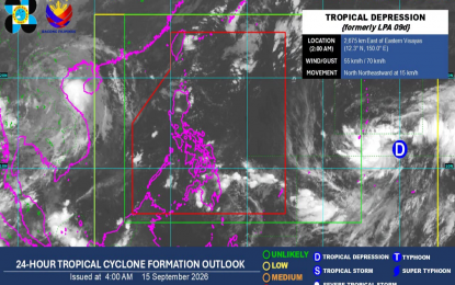
A low-pressure area (LPA) that developed into a tropical depression may enter the Philippine Area of Responsibility (PAR) in the coming days, according to the Philippine Atmospheric, Geophysical and Astronomical Services Administration (PAGASA) on Tuesday.
In its 5 a.m. weather bulletin, PAGASA reported that the tropical cyclone was located approximately 2,675 kilometers east of Eastern Visayas. It was moving north-northeastward at 15 kilometers per hour, with maximum sustained winds of 55 kph near the center and gustiness of up to 70 kph.
PAGASA weather forecaster Veronica Torres said, however, that the tropical cyclone is not expected to make landfall or have a direct effect on any part of the country.
Meanwhile, the easterlies will continue to affect the country, bringing partly cloudy to cloudy skies, along with isolated rain showers or thunderstorms over Batanes and the Babuyan Islands.
Metro Manila and the rest of the country will also experience isolated rain showers caused by localized thunderstorms.
Light to moderate winds and slight to moderate coastal waters are expected across the entire archipelago.

